
exp_12 Feb 2023 at 20-36-48.gpx

Tourisme Equestre Alsace
Promouvoir le Tourisme Equestre en Alsace GUIDE+
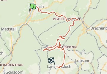

Length
16.7 km

Max alt
489 m

Uphill gradient
417 m
Km-Effort
22 km

Min alt
190 m

Downhill gradient
410 m
Boucle
No
Creation date :
2023-02-13 18:38:14.608
Updated on :
2023-02-13 18:41:56.097
0m
Difficulty : Medium

FREE GPS app for hiking
 SityTrail
IGN / Geographical institutes
SityTrail Plus
The world is yours!
About
Trail Coupling of 16.7 km to be discovered at Grand Est, Bas-Rhin, Lembach. This trail is proposed by Tourisme Equestre Alsace.
Photos

Positioning
Country:
France
Region :
Grand Est
Department/Province :
Bas-Rhin
Municipality :
Lembach
Location:
Unknown
Start:(Dec)
Start:(UTM)
410940 ; 5428017 (32U) N.
Comments