


satillieux

nordan
User
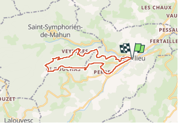

Length
14.7 km

Max alt
931 m

Uphill gradient
632 m
Km-Effort
23 km

Min alt
481 m

Downhill gradient
628 m
Boucle
Yes
Creation date :
2023-02-07 08:31:48.211
Updated on :
2023-02-14 07:03:37.382
5h08
Difficulty : Very difficult

FREE GPS app for hiking
 SityTrail
IGN / Geographical institutes
SityTrail Plus
The world is yours!
About
Trail Walking of 14.7 km to be discovered at Auvergne-Rhône-Alpes, Ardèche, Satillieu. This trail is proposed by nordan.
Positioning
Country:
France
Region :
Auvergne-Rhône-Alpes
Department/Province :
Ardèche
Municipality :
Satillieu
Location:
Unknown
Start:(Dec)
Start:(UTM)
626909 ; 5000884 (31T) N.
Comments