


ophness
User
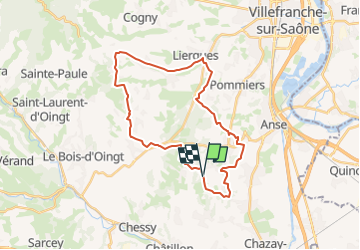

Length
29 km

Max alt
494 m

Uphill gradient
735 m
Km-Effort
39 km

Min alt
218 m

Downhill gradient
723 m
Boucle
Yes
Creation date :
2023-02-14 08:24:21.678
Updated on :
2023-02-14 08:24:21.678

FREE GPS app for hiking
 SityTrail
IGN / Geographical institutes
SityTrail Plus
The world is yours!
About
Trail of 29 km to be discovered at Auvergne-Rhône-Alpes, Rhône, Marcy. This trail is proposed by ophness.
Positioning
Country:
France
Region :
Auvergne-Rhône-Alpes
Department/Province :
Rhône
Municipality :
Marcy
Location:
Unknown
Start:(Dec)
Start:(UTM)
629379 ; 5085635 (31T) N.
Comments