


sarrians 84 tourreau temerlet

aupi
User
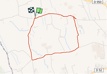

Length
4.1 km

Max alt
47 m

Uphill gradient
22 m
Km-Effort
4.4 km

Min alt
34 m

Downhill gradient
23 m
Boucle
Yes
Creation date :
2023-02-08 14:01:31.43
Updated on :
2023-02-14 08:43:50.943
1h12
Difficulty : Very easy

FREE GPS app for hiking
 SityTrail
IGN / Geographical institutes
SityTrail Plus
The world is yours!
About
Trail Walking of 4.1 km to be discovered at Provence-Alpes-Côte d'Azur, Vaucluse, Sarrians. This trail is proposed by aupi.
Positioning
Country:
France
Region :
Provence-Alpes-Côte d'Azur
Department/Province :
Vaucluse
Municipality :
Sarrians
Location:
Unknown
Start:(Dec)
Start:(UTM)
655268 ; 4883589 (31T) N.
Comments