


z le catchéou 2 14-02-23

cb8310
User
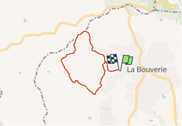

Length
6.3 km

Max alt
88 m

Uphill gradient
82 m
Km-Effort
7.4 km

Min alt
32 m

Downhill gradient
81 m
Boucle
Yes
Creation date :
2023-02-14 13:18:14.386
Updated on :
2023-02-15 15:10:05.713
2h06
Difficulty : Very easy

FREE GPS app for hiking
 SityTrail
IGN / Geographical institutes
SityTrail Plus
The world is yours!
About
Trail Walking of 6.3 km to be discovered at Provence-Alpes-Côte d'Azur, Var, Roquebrune-sur-Argens. This trail is proposed by cb8310.
Description
aucune difficulté dans cette rando sur de larges pistes
Positioning
Country:
France
Region :
Provence-Alpes-Côte d'Azur
Department/Province :
Var
Municipality :
Roquebrune-sur-Argens
Location:
Unknown
Start:(Dec)
Start:(UTM)
308830 ; 4819102 (32T) N.
Comments