


EQU-INTEGRALE-2021

aeldin
User
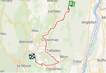

Length
22 km

Max alt
1189 m

Uphill gradient
244 m
Km-Effort
28 km

Min alt
230 m

Downhill gradient
1054 m
Boucle
No
Creation date :
2023-02-14 19:00:12.314
Updated on :
2023-05-04 15:14:40.396
3h40
Difficulty : Medium

FREE GPS app for hiking
 SityTrail
IGN / Geographical institutes
SityTrail Plus
The world is yours!
About
Trail Horseback riding of 22 km to be discovered at Auvergne-Rhône-Alpes, Ain, Arvière-en-Valromey. This trail is proposed by aeldin.

Positioning
Country:
France
Region :
Auvergne-Rhône-Alpes
Department/Province :
Ain
Municipality :
Arvière-en-Valromey
Location:
Lochieu
Start:(Dec)
Start:(UTM)
713926 ; 5090153 (31T) N.
Comments