


iytes

Clo0413
User
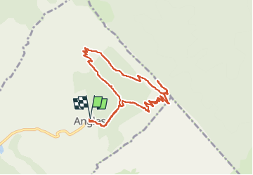

Length
9.6 km

Max alt
1593 m

Uphill gradient
645 m
Km-Effort
18.2 km

Min alt
968 m

Downhill gradient
644 m
Boucle
Yes
Creation date :
2023-02-15 08:52:14.574
Updated on :
2023-02-15 14:31:40.334
3h08
Difficulty : Difficult

FREE GPS app for hiking
 SityTrail
IGN / Geographical institutes
SityTrail Plus
The world is yours!
About
Trail Walking of 9.6 km to be discovered at Provence-Alpes-Côte d'Azur, Alpes-de-Haute-Provence, Angles. This trail is proposed by Clo0413.
Positioning
Country:
France
Region :
Provence-Alpes-Côte d'Azur
Department/Province :
Alpes-de-Haute-Provence
Municipality :
Angles
Location:
Unknown
Start:(Dec)
Start:(UTM)
304062 ; 4868458 (32T) N.
Comments