Trail Walking Sauve - GORGES DU CRESPENOU - Photo

GORGES DU CRESPENOU

© OpenStreetMap contributors
Length
Length
17.1 km
Max alt
Max alt
342 m
Uphill gradient
Uphill gradient
482 m
Km-Effort
Km-Effort  
24 km
Min alt
Min alt
124 m
Downhill gradient
Downhill gradient
478 m
Boucle
Boucle
Yes
Creation date :
2014-12-10 00:00:00.0
Updated on :
2014-12-10 00:00:00.0

(2 Reviews)

Walking
Walking
--
Difficulty : Unknown

Scan this QR Code to open this trail in the SityTrail application

FREE GPS app for hiking

Logo SityTrail SityTrail

IGN / Geographical institutes

Download SityTrail from the App Store Download SityTrail from Google Play

Logo SityTrail SityTrail World

The world is yours!

Download SityTrail from the App Store Download SityTrail from Google Play Download SityTrail on Huawei AppGallery

About

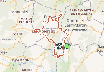
Trail Walking of 17.1 km to be discovered at Occitania, Gard, Sauve. This trail is proposed by didier.zimmermann.

Description

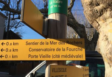
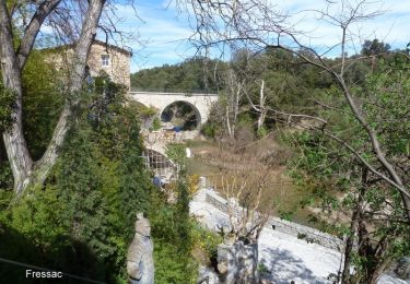
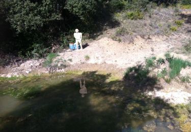
GORGES DU CRESPENOU - CHATEAU DE FRESSACDépart randonnée : Du lieu- dit La Selve 2km500 avant d'arriver à Dufort sur la D117 Parking pour 6 Voitures (Gard 30)  Les gorges du Crespenou et le chateau de Fressac A la base cette trace a été déposée par le Petit Soulier et une erreur dès le départ nous a conduit jusqu'au gorges du Crespenou, nous avons fait un aller-retour qui nous a permis d'admirer un site à ne pas manquer, la rivière a creusé des marmites dans un défilé absolument superbe, le reste est parfaitement fidèle à la description du petit Soulier sur la rando intitulée: "Le chateau de Fressac"Bonne randonnée Merci Perdigal30 pour cette trace gps RANDOGPS.NET

Elevation profile

Positioning

Country:
France
Region :
Occitania
Department/Province :
Gard
Municipality :
Sauve
Location:
Unknown
Start:(UTM)
575499 ; 4868521 (31T) N.

Comments

Please log in to post a review or rate the element


belle ballade facile. une variante intéressante suivre le sentier de crête du château du Castellas


Trails nearby

Trail Walking Sauve - Chateau de Freissac / le Crespou - Photo
Walking
GUIDE
nadinebondoux

Walking

Medium
Sauve, Occitania, Gard, France
16.8 km | 23 km-effort
5h 40min
Yes
Trail Walking Sauve - Sauve, le sentier de l'Aven - Photo
Walking
PatCoria

Walking

Easy
(1)
Sauve, Occitania, Gard, France
4.2 km | 5.4 km-effort
1h 30min
Yes
Trail Walking Durfort-et-Saint-Martin-de-Sossenac - circuit Durfort 2 - Photo
Walking
jeanjacques13

Walking

Easy
(1)
Durfort-et-Saint-Martin-de-Sossenac, Occitania, Gard, France
8.1 km | 9.9 km-effort
2h 8min
Yes
Trail Walking Conqueyrac - les 2 jumelles près de St hippolythe - Photo
Walking
labarone

Walking

Medium
Conqueyrac, Occitania, Gard, France
17.5 km | 25 km-effort
6h 3min
Yes
Trail Walking Sauve - Sauve-Quissac-Vidourle - Photo
Walking
v.rabot

Walking

Difficult
Sauve, Occitania, Gard, France
22 km | 30 km-effort
6h 49min
Yes
Trail Trail Sauve - Sauve - Photo
Trail
Daniel Habert

Trail

Very easy
(1)
Sauve, Occitania, Gard, France
4.2 km | 4.6 km-effort
35min
Yes
Trail Walking Sauve - Sauve - Mer des rochers  - Photo
Walking
campingmasdelacam

Walking

(1)
Sauve, Occitania, Gard, France
4.9 km | 6 km-effort
1h 30min
Yes
Trail Walking Sauve - Château Fressac - Sauve - Photo
Walking
tracegps

Walking

Difficult
Sauve, Occitania, Gard, France
16.3 km | 22 km-effort
6h 0min
Yes
Trail Walking Monoblet - autour de Monoblet par Gourgas - Photo
Walking
genevieve

Walking

Medium
(2)
Monoblet, Occitania, Gard, France
12 km | 15.7 km-effort
3h 22min
Yes


Close
My subscriptions