


Marolles 10

togolo28
User
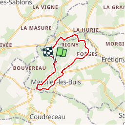

Length
10.3 km

Max alt
220 m

Uphill gradient
208 m
Km-Effort
13.1 km

Min alt
142 m

Downhill gradient
208 m
Boucle
Yes
Creation date :
2014-12-10 00:00:00.0
Updated on :
2019-09-11 15:06:55.815
2h51
Difficulty : Easy

FREE GPS app for hiking
 SityTrail
IGN / Geographical institutes
SityTrail Plus
The world is yours!
About
Trail Walking of 10.3 km to be discovered at Centre-Loire Valley, Eure-et-Loir, Marolles-les-Buis. This trail is proposed by togolo28.
Positioning
Country:
France
Region :
Centre-Loire Valley
Department/Province :
Eure-et-Loir
Municipality :
Marolles-les-Buis
Location:
Unknown
Start:(Dec)
Start:(UTM)
346508 ; 5359664 (31U) N.
Comments