Trail Walking Maussane-les-Alpilles - Les gypieres     Maussane  les Alpilles - Photo
 lesgara
lesgara

User

© OpenStreetMap contributors
Length
Length
12.1 km
Max alt
Max alt
222 m
Uphill gradient
Uphill gradient
338 m
Km-Effort
Km-Effort  
16.6 km
Min alt
Min alt
62 m
Downhill gradient
Downhill gradient
342 m
Boucle
Boucle
Yes
Creation date :
2023-02-16 10:33:29.99
Updated on :
2023-02-16 10:36:03.643

(0 Reviews)

Walking
Walking
3h46
Difficulty : Difficult

Scan this QR Code to open this trail in the SityTrail application

FREE GPS app for hiking

Logo SityTrail SityTrail

IGN / Geographical institutes

Download SityTrail from the App Store Download SityTrail from Google Play

Logo SityTrail SityTrail World

The world is yours!

Download SityTrail from the App Store Download SityTrail from Google Play Download SityTrail on Huawei AppGallery

About

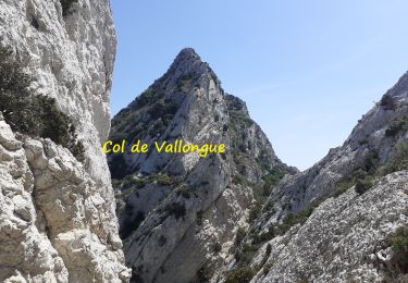
Trail Walking of 12.1 km to be discovered at Provence-Alpes-Côte d'Azur, Bouches-du-Rhône, Maussane-les-Alpilles. This trail is proposed by lesgara.

Description

Rando tres agreable de 11km500  qui meriterait d etre rallongée pour en faire une a la journée

Elevation profile

Positioning

Country:
France
Region :
Provence-Alpes-Côte d'Azur
Department/Province :
Bouches-du-Rhône
Municipality :
Maussane-les-Alpilles
Location:
Unknown
Start:(UTM)
649647 ; 4842624 (31T) N.

Trails nearby

Trail Walking Saint-Rémy-de-Provence - Les Alpilles pas de l aigle - Photo
Walking
pierrot30

Walking

Medium
(2)
Saint-Rémy-de-Provence, Provence-Alpes-Côte d'Azur, Bouches-du-Rhône, France
10.3 km | 14 km-effort
3h 44min
Yes
Trail Walking Saint-Rémy-de-Provence - PF-Saint-Rémy-de-Provence - La Piste des Lombards - Photo
Walking
MicDul

Walking

Easy
(1)
Saint-Rémy-de-Provence, Provence-Alpes-Côte d'Azur, Bouches-du-Rhône, France
7.6 km | 10.1 km-effort
2h 15min
Yes
Trail Walking Les Baux-de-Provence - Maussane - Vallon des amants - les grands Calans - Photo
Walking
Nathy8913

Walking

Medium
(2)
Les Baux-de-Provence, Provence-Alpes-Côte d'Azur, Bouches-du-Rhône, France
16.1 km | 22 km-effort
5h 5min
Yes
Trail Walking Maussane-les-Alpilles - Tour des Trincades - Photo
Walking
Amaralain

Walking

Medium
(1)
Maussane-les-Alpilles, Provence-Alpes-Côte d'Azur, Bouches-du-Rhône, France
9.5 km | 13.5 km-effort
2h 55min
Yes
Trail Walking Maussane-les-Alpilles - Maussane Les Baux Maussane - Photo
Walking
hervef13300

Walking

Medium
(2)
Maussane-les-Alpilles, Provence-Alpes-Côte d'Azur, Bouches-du-Rhône, France
15 km | 19.2 km-effort
4h 12min
No
Trail sport Saint-Rémy-de-Provence - 2024-02-04_13h04m18_COURSE_246375352 - Photo
sport
DL72

sport

Very easy
(1)
Saint-Rémy-de-Provence, Provence-Alpes-Côte d'Azur, Bouches-du-Rhône, France
16.6 km | 21 km-effort
Unknown
Yes
Trail Walking Les Baux-de-Provence - les Baux de Provence  - Photo
Walking
alinetpierre

Walking

Medium
Les Baux-de-Provence, Provence-Alpes-Côte d'Azur, Bouches-du-Rhône, France
16 km | 21 km-effort
3h 51min
Yes
Trail Walking Saint-Rémy-de-Provence - St Remy de Pce. Chemin des Lombars - Photo
Walking
Manoune

Walking

Medium
(1)
Saint-Rémy-de-Provence, Provence-Alpes-Côte d'Azur, Bouches-du-Rhône, France
12.8 km | 16.9 km-effort
4h 1min
Yes
Trail Walking Saint-Rémy-de-Provence - Crête des Alpilles (Rocher des 2 Trous) - Photo
Walking
donda

Walking

Very difficult
Saint-Rémy-de-Provence, Provence-Alpes-Côte d'Azur, Bouches-du-Rhône, France
16.2 km | 23 km-effort
4h 58min
Yes


Close
My subscriptions