


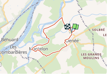
/49/Denée/Parcours de l'après-midi
Association ARCA49
Autour de la randonnée

Length
6.5 km

Max alt
33 m

Uphill gradient
46 m
Km-Effort
7.1 km

Min alt
11 m

Downhill gradient
46 m
Boucle
Yes
Creation date :
2023-02-16 10:56:17.482
Updated on :
2023-02-16 11:06:04.583
1h37
Difficulty : Medium

FREE GPS app for hiking
 SityTrail
IGN / Geographical institutes
SityTrail Plus
The world is yours!
About
Trail Walking of 6.5 km to be discovered at Pays de la Loire, Maine-et-Loire, Denée. This trail is proposed by Association ARCA49.
Description
Départ du plan d'eau, route de St Jean de la Croix
Positioning
Country:
France
Region :
Pays de la Loire
Department/Province :
Maine-et-Loire
Municipality :
Denée
Location:
Unknown
Start:(Dec)
Start:(UTM)
680535 ; 5250361 (30T) N.
Comments