


Le long de Comberoufle

aldaus
User
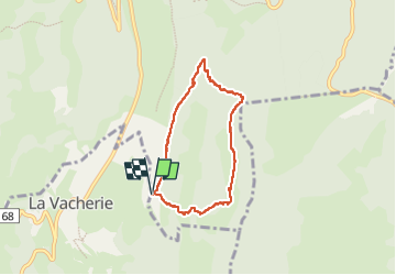

Length
5.9 km

Max alt
1381 m

Uphill gradient
436 m
Km-Effort
11.7 km

Min alt
951 m

Downhill gradient
437 m
Boucle
Yes
Creation date :
2023-02-17 06:53:12.299
Updated on :
2023-02-17 10:08:50.703
2h45
Difficulty : Medium

FREE GPS app for hiking
 SityTrail
IGN / Geographical institutes
SityTrail Plus
The world is yours!
About
Trail Walking of 5.9 km to be discovered at Auvergne-Rhône-Alpes, Drôme, Léoncel. This trail is proposed by aldaus.
Positioning
Country:
France
Region :
Auvergne-Rhône-Alpes
Department/Province :
Drôme
Municipality :
Léoncel
Location:
Unknown
Start:(Dec)
Start:(UTM)
673397 ; 4972842 (31T) N.
Comments