


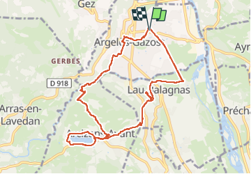
Trace Argeles G4 Guy

mitch1952
User

Length
10.8 km

Max alt
662 m

Uphill gradient
324 m
Km-Effort
15.1 km

Min alt
428 m

Downhill gradient
325 m
Boucle
Yes
Creation date :
2023-02-17 08:47:56.0
Updated on :
2023-02-17 16:54:41.0
5h18
Difficulty : Unknown

FREE GPS app for hiking
 SityTrail
IGN / Geographical institutes
SityTrail Plus
The world is yours!
About
Trail Walking of 10.8 km to be discovered at Occitania, Hautespyrenees, Argelès-Gazost. This trail is proposed by mitch1952.
Positioning
Country:
France
Region :
Occitania
Department/Province :
Hautespyrenees
Municipality :
Argelès-Gazost
Location:
Unknown
Start:(Dec)
Start:(UTM)
736773 ; 4765728 (30T) N.
Comments