


17/02

Yolande Olivier
User

Length
13.4 km

Max alt
94 m

Uphill gradient
169 m
Km-Effort
15.6 km

Min alt
30 m

Downhill gradient
168 m
Boucle
Yes
Creation date :
2023-02-17 12:43:10.168
Updated on :
2023-02-17 15:40:44.377
2h56
Difficulty : Difficult

FREE GPS app for hiking
 SityTrail
IGN / Geographical institutes
SityTrail Plus
The world is yours!
About
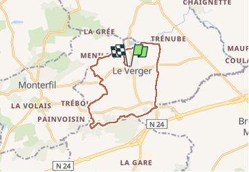
Trail Walking of 13.4 km to be discovered at Brittany, Ille-et-Vilaine, Le Verger. This trail is proposed by Yolande Olivier.
Description
ffrp
Positioning
Country:
France
Region :
Brittany
Department/Province :
Ille-et-Vilaine
Municipality :
Le Verger
Location:
Unknown
Start:(Dec)
Start:(UTM)
579499 ; 5324789 (30U) N.
Comments