Trail Walking Ottrott - Le mur païen - Photo
© OpenStreetMap contributors
Length
Length
10.5 km
Max alt
Max alt
831 m
Uphill gradient
Uphill gradient
298 m
Km-Effort
Km-Effort  
14.5 km
Min alt
Min alt
590 m
Downhill gradient
Downhill gradient
284 m
Boucle
Boucle
Yes
Creation date :
2014-12-10 00:00:00.0
Updated on :
2014-12-10 00:00:00.0

(4 Reviews)

Walking
Walking
4h36
Difficulty : Medium

Scan this QR Code to open this trail in the SityTrail application

FREE GPS app for hiking

Logo SityTrail SityTrail

IGN / Geographical institutes

Download SityTrail from the App Store Download SityTrail from Google Play

Logo SityTrail SityTrail World

The world is yours!

Download SityTrail from the App Store Download SityTrail from Google Play Download SityTrail on Huawei AppGallery

About

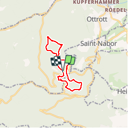
Trail Walking of 10.5 km to be discovered at Grand Est, Bas-Rhin, Ottrott. This trail is proposed by VacheKiri67.

Description

Faite le 20/10/2014 avec notre fils de 10 ans et nos amis Monique et Patrice, Francine et Christian et leur fils Marc, Claudine et sa fille Anne. D'après : TOPO GUIDE Au coeur de l'Alsace - N°2 Sainte-Odile : le mur "païen". La durée indiquée pour le circuit est de 3h30. Dans notre cas elle fut rallongée pour cause de cueillette de champignons.

Elevation profile

Photos

Positioning

Country:
France
Region :
Grand Est
Department/Province :
Bas-Rhin
Municipality :
Ottrott
Location:
Unknown
Start:(UTM)
381642 ; 5365675 (32U) N.

Comments

Please log in to post a review or rate the element


Oups, la fenêtre s'est fermée avant que je donne la bonne note.


Merci VacheKiri pour ton circuit que je me suis permis de copier pour réaliser une magnifique rando.


Un lieu magique !


Trails nearby

Trail Walking Ottrott - Le circuit sud du Mur Païen - Photo
Walking
VacheKiri67

Walking

Easy
(2)
Ottrott, Grand Est, Bas-Rhin, France
4.9 km | 6.3 km-effort
1h 56min
No
Trail Walking Ottrott - Le circuit nord du Mur Païen - Photo
Walking
VacheKiri67

Walking

Easy
(1)
Ottrott, Grand Est, Bas-Rhin, France
5.9 km | 8.5 km-effort
2h 4min
No
Trail Walking Ottrott - Le Mont Sainte-Odile depuis Otrott - Photo
Walking
VacheKiri67

Walking

Medium
(1)
Ottrott, Grand Est, Bas-Rhin, France
13 km | 20 km-effort
6h 18min
Yes
Trail Walking Ottrott - Montée vers le Mont Sainte-Odile - Photo
Walking
VacheKiri67

Walking

Difficult
(1)
Ottrott, Grand Est, Bas-Rhin, France
17.6 km | 26 km-effort
5h 52min
Yes
Trail Walking Ottrott - Mur Paien complet - Photo
Walking
markrei

Walking

Medium
(1)
Ottrott, Grand Est, Bas-Rhin, France
12 km | 16.4 km-effort
5h 25min
Yes
Trail Mountain bike Barr - Circuit des 3 Petits Ponts - Photo
Mountain bike
tracegps

Mountain bike

Difficult
(1)
Barr, Grand Est, Bas-Rhin, France
15.9 km | 22 km-effort
1h 19min
Yes
Trail Mountain bike Ottrott - Sainte-Odile East-Face - Photo
Mountain bike
tracegps

Mountain bike

Difficult
(1)
Ottrott, Grand Est, Bas-Rhin, France
24 km | 39 km-effort
3h 0min
Yes
Trail Walking Obernai - sentier des merveilles - Photo
Walking
semila

Walking

Difficult
(1)
Obernai, Grand Est, Bas-Rhin, France
11 km | 16.6 km-effort
4h 8min
Yes
Trail Walking Ottrott - 2013-12-29 Marche Mt Ste Odile Maennelstein Birkenfels - Photo
Walking
GUIDE
holtzv

Walking

Medium
(1)
Ottrott, Grand Est, Bas-Rhin, France
10.8 km | 15.4 km-effort
3h 24min
Yes


Close
My subscriptions