


soultz jesselberg

gamille67
User
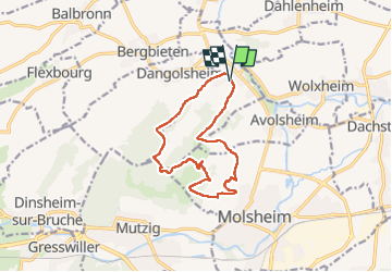

Length
11.9 km

Max alt
360 m

Uphill gradient
414 m
Km-Effort
17.4 km

Min alt
183 m

Downhill gradient
414 m
Boucle
Yes
Creation date :
2022-12-27 09:29:36.902
Updated on :
2023-02-18 13:11:07.909
2h44
Difficulty : Very easy

FREE GPS app for hiking
 SityTrail
IGN / Geographical institutes
SityTrail Plus
The world is yours!
About
Trail Walking of 11.9 km to be discovered at Grand Est, Bas-Rhin, Soultz-les-Bains. This trail is proposed by gamille67.
Positioning
Country:
France
Region :
Grand Est
Department/Province :
Bas-Rhin
Municipality :
Soultz-les-Bains
Location:
Unknown
Start:(Dec)
Start:(UTM)
388220 ; 5380804 (32U) N.
Comments