


Vierzon

lecmic
User
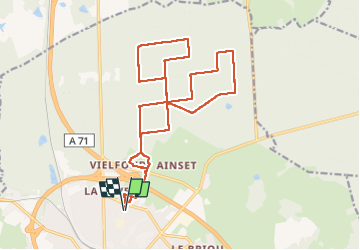

Length
21 km

Max alt
191 m

Uphill gradient
145 m
Km-Effort
22 km

Min alt
145 m

Downhill gradient
145 m
Boucle
Yes
Creation date :
2023-02-19 06:05:50.82
Updated on :
2023-02-19 09:39:59.082
3h33
Difficulty : Easy

FREE GPS app for hiking
 SityTrail
IGN / Geographical institutes
SityTrail Plus
The world is yours!
About
Trail Walking of 21 km to be discovered at Centre-Loire Valley, Cher, Vierzon. This trail is proposed by lecmic.
Description
rando école du colombier
Positioning
Country:
France
Region :
Centre-Loire Valley
Department/Province :
Cher
Municipality :
Vierzon
Location:
Unknown
Start:(Dec)
Start:(UTM)
429496 ; 5231874 (31T) N.
Comments