


Crête de Azet

chasle
User
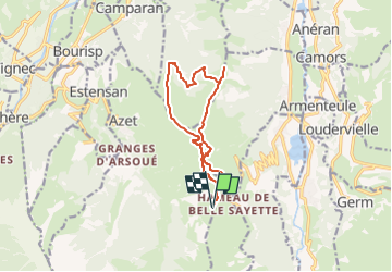

Length
12.2 km

Max alt
1736 m

Uphill gradient
526 m
Km-Effort
19.3 km

Min alt
1475 m

Downhill gradient
530 m
Boucle
Yes
Creation date :
2023-02-19 19:55:22.57
Updated on :
2023-02-19 19:56:43.81
0m
Difficulty : Difficult

FREE GPS app for hiking
 SityTrail
IGN / Geographical institutes
SityTrail Plus
The world is yours!
About
Trail Snowshoes of 12.2 km to be discovered at Occitania, Hautespyrenees, Azet. This trail is proposed by chasle.
Positioning
Country:
France
Region :
Occitania
Department/Province :
Hautespyrenees
Municipality :
Azet
Location:
Unknown
Start:(Dec)
Start:(UTM)
285773 ; 4741009 (31T) N.
Comments