


DUZON

nordan
User

Length
16.4 km

Max alt
452 m

Uphill gradient
770 m
Km-Effort
27 km

Min alt
130 m

Downhill gradient
776 m
Boucle
Yes
Creation date :
2023-02-19 09:14:57.882
Updated on :
2023-02-20 08:26:17.671
5h36
Difficulty : Medium

FREE GPS app for hiking
 SityTrail
IGN / Geographical institutes
SityTrail Plus
The world is yours!
About
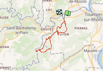
Trail Walking of 16.4 km to be discovered at Auvergne-Rhône-Alpes, Ardèche, Tournon-sur-Rhône. This trail is proposed by nordan.
Positioning
Country:
France
Region :
Auvergne-Rhône-Alpes
Department/Province :
Ardèche
Municipality :
Tournon-sur-Rhône
Location:
Unknown
Start:(Dec)
Start:(UTM)
641470 ; 4991762 (31T) N.
Comments