


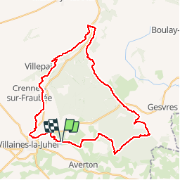
A faire Corniche de Pail Haute Mayenne

mimi53
User

Length
36 km

Max alt
387 m

Uphill gradient
655 m
Km-Effort
44 km

Min alt
148 m

Downhill gradient
652 m
Boucle
Yes
Creation date :
2019-02-23 20:41:47.812
Updated on :
2019-02-23 20:41:47.844
5h27
Difficulty : Medium

FREE GPS app for hiking
 SityTrail
IGN / Geographical institutes
SityTrail Plus
The world is yours!
About
Trail Equestrian of 36 km to be discovered at Pays de la Loire, Mayenne, Averton. This trail is proposed by mimi53.
Positioning
Country:
France
Region :
Pays de la Loire
Department/Province :
Mayenne
Municipality :
Averton
Location:
Unknown
Start:(Dec)
Start:(UTM)
704153 ; 5358536 (30U) N.
Comments