


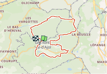
Les étangs de Girmont et le prieuré d’Herival

francoisecarlier
User

Length
18.8 km

Max alt
746 m

Uphill gradient
477 m
Km-Effort
25 km

Min alt
478 m

Downhill gradient
479 m
Boucle
Yes
Creation date :
2023-02-20 09:22:32.0
Updated on :
2023-02-20 14:43:51.341
5h15
Difficulty : Easy

FREE GPS app for hiking
 SityTrail
IGN / Geographical institutes
SityTrail Plus
The world is yours!
About
Trail Walking of 18.8 km to be discovered at Grand Est, Vosges, Girmont-Val-d'Ajol. This trail is proposed by francoisecarlier.
Photos


Positioning
Country:
France
Region :
Grand Est
Department/Province :
Vosges
Municipality :
Girmont-Val-d'Ajol
Location:
Unknown
Start:(Dec)
Start:(UTM)
317760 ; 5314134 (32T) N.
Comments