


papillon2

ophness
User
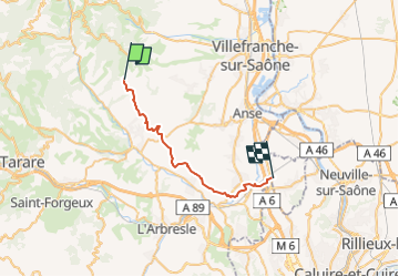

Length
26 km

Max alt
539 m

Uphill gradient
455 m
Km-Effort
33 km

Min alt
185 m

Downhill gradient
783 m
Boucle
No
Creation date :
2023-02-20 22:19:18.67
Updated on :
2023-02-20 22:19:38.383
4h23
Difficulty : Difficult

FREE GPS app for hiking
 SityTrail
IGN / Geographical institutes
SityTrail Plus
The world is yours!
About
Trail Horseback riding of 26 km to be discovered at Auvergne-Rhône-Alpes, Rhône, Sainte-Paule. This trail is proposed by ophness.
Positioning
Country:
France
Region :
Auvergne-Rhône-Alpes
Department/Province :
Rhône
Municipality :
Sainte-Paule
Location:
Unknown
Start:(Dec)
Start:(UTM)
621214 ; 5091333 (31T) N.
Comments