


2023-02-21_00h03m43_E2_OUARZAZATE-DADES_360km

jpipacific
User
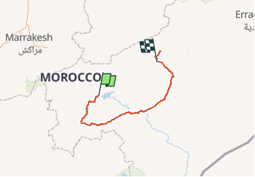

Length
362 km

Max alt
2308 m

Uphill gradient
5558 m
Km-Effort
435 km

Min alt
877 m

Downhill gradient
5084 m
Boucle
No
Creation date :
2023-02-20 23:03:43.559
Updated on :
2023-02-21 17:07:13.723
5h00
Difficulty : Medium

FREE GPS app for hiking
 SityTrail
IGN / Geographical institutes
SityTrail Plus
The world is yours!
About
Trail Moto cross of 362 km to be discovered at Drâa-Tafilalet, Pachalik d'Ouarzazate, Ouarzazate. This trail is proposed by jpipacific.
Description
info Anto
Positioning
Country:
Morocco
Region :
Drâa-Tafilalet
Department/Province :
Pachalik d'Ouarzazate
Municipality :
Ouarzazate
Location:
Unknown
Start:(Dec)
Start:(UTM)
700563 ; 3422662 (29R) N.
Comments