


PR_56_Pluneret_AB_04_Les-Deux-Rivieres_Circuit1b_20230221

patrickdanilo
User

Length
12.2 km

Max alt
34 m

Uphill gradient
126 m
Km-Effort
13.9 km

Min alt
0 m

Downhill gradient
125 m
Boucle
Yes
Creation date :
2023-02-21 09:28:18.15
Updated on :
2025-07-28 12:40:39.048
2h52
Difficulty : Easy

FREE GPS app for hiking
 SityTrail
IGN / Geographical institutes
SityTrail Plus
The world is yours!
About
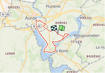
Trail Walking of 12.2 km to be discovered at Brittany, Morbihan, Pluneret. This trail is proposed by patrickdanilo.
Description
Randonnée Marche de 12,2 km à découvrir à Bretagne, Morbihan, Pluneret. Cette randonnée est proposée par patrickdanilo.
Photos


33 photos in total. Please click on a photo to see them all in the gallery.
Positioning
Country:
France
Region :
Brittany
Department/Province :
Morbihan
Municipality :
Pluneret
Location:
Unknown
Start:(Dec)
Start:(UTM)
503645 ; 5277732 (30T) N.
Comments