


Augas

pacha56
User
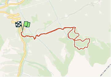

Length
5.3 km

Max alt
1918 m

Uphill gradient
364 m
Km-Effort
10.1 km

Min alt
1552 m

Downhill gradient
365 m
Boucle
Yes
Creation date :
2023-02-22 09:09:13.25
Updated on :
2023-02-22 14:44:20.713
5h34
Difficulty : Medium

FREE GPS app for hiking
 SityTrail
IGN / Geographical institutes
SityTrail Plus
The world is yours!
About
Trail Walking of 5.3 km to be discovered at Occitania, Hautespyrenees, Aragnouet. This trail is proposed by pacha56.
Description
Randonnée raquettes très agréable
Positioning
Country:
France
Region :
Occitania
Department/Province :
Hautespyrenees
Municipality :
Aragnouet
Location:
Unknown
Start:(Dec)
Start:(UTM)
270825 ; 4739592 (31T) N.
Comments