Trail Walking Châtillon-en-Diois - Le Mayor - Photo
 OscarMa
OscarMa

User

© OpenStreetMap contributors
Length
Length
22 km
Max alt
Max alt
1487 m
Uphill gradient
Uphill gradient
1474 m
Km-Effort
Km-Effort  
42 km
Min alt
Min alt
586 m
Downhill gradient
Downhill gradient
1504 m
Boucle
Boucle
No
Creation date :
2014-12-28 00:00:00.0
Updated on :
2014-12-28 00:00:00.0

(0 Reviews)

Walking
Walking
8h17
Difficulty : Difficult

Scan this QR Code to open this trail in the SityTrail application

FREE GPS app for hiking

Logo SityTrail SityTrail

IGN / Geographical institutes

Download SityTrail from the App Store Download SityTrail from Google Play

Logo SityTrail SityTrail World

The world is yours!

Download SityTrail from the App Store Download SityTrail from Google Play Download SityTrail on Huawei AppGallery

About

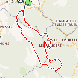
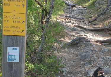
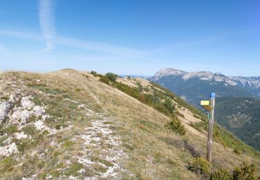
Trail Walking of 22 km to be discovered at Auvergne-Rhône-Alpes, Drôme, Châtillon-en-Diois. This trail is proposed by OscarMa.

Description

De la Ferme d'Ombre monter au Mayor Près de la Grésière

Elevation profile

Photos

Points of interest

Point of interest Boulc - Ravel - Photo
OscarMa
BOULC 
Point of interest Boulc - Le Mayor  - Photo
OscarMa
BOULC 

Positioning

Country:
France
Region :
Auvergne-Rhône-Alpes
Department/Province :
Drôme
Municipality :
Châtillon-en-Diois
Location:
Châtillon-en-Diois
Start:(UTM)
698034 ; 4951187 (31T) N.

Trails nearby

Trail Walking Châtillon-en-Diois - chatillon en Diois, GR91 - Photo
Walking
francislassauce

Walking

Difficult
(1)
Châtillon-en-Diois, Auvergne-Rhône-Alpes, Drôme, France
7.8 km | 14.3 km-effort
3h 14min
Yes
Trail Walking Châtillon-en-Diois - Pas des CLots - Photo
Walking
OscarMa

Walking

Difficult
(1)
Châtillon-en-Diois, Auvergne-Rhône-Alpes, Drôme, France
16.1 km | 34 km-effort
7h 15min
Yes
Trail Walking Châtillon-en-Diois - glandasse par chatillon - Photo
Walking
pphilippe

Walking

Medium
(1)
Châtillon-en-Diois, Auvergne-Rhône-Alpes, Drôme, France
15.4 km | 32 km-effort
4h 45min
Yes
Trail Walking Châtillon-en-Diois - Pellebit - Photo
Walking
ajd26

Walking

Very difficult
Châtillon-en-Diois, Auvergne-Rhône-Alpes, Drôme, France
14.2 km | 27 km-effort
6h 13min
Yes
Trail Walking Châtillon-en-Diois - Circuit des Baumes - Pont de vachères-Soubreroche - Boulc - Photo
Walking
Philindy26

Walking

Medium
Châtillon-en-Diois, Auvergne-Rhône-Alpes, Drôme, France
11.4 km | 18.5 km-effort
4h 20min
Yes
Trail Walking Châtillon-en-Diois - Cabane de Chatillon  - Photo
Walking
Atchoum26

Walking

Medium
Châtillon-en-Diois, Auvergne-Rhône-Alpes, Drôme, France
17.6 km | 37 km-effort
6h 4min
No
Trail Walking Châtillon-en-Diois - chatillon en Diois. les oursieres  - Photo
Walking
francislassauce

Walking

Difficult
Châtillon-en-Diois, Auvergne-Rhône-Alpes, Drôme, France
8.6 km | 15.1 km-effort
4h 42min
Yes
Trail Walking Châtillon-en-Diois - Chatillon en Diois la cabane - Photo
Walking
Atchoum26

Walking

Medium
Châtillon-en-Diois, Auvergne-Rhône-Alpes, Drôme, France
17 km | 33 km-effort
7h 9min
Yes
Trail Walking Menglon - La Grésière à partir des Gallands - Menglon - Photo
Walking
Philindy26

Walking

Difficult
Menglon, Auvergne-Rhône-Alpes, Drôme, France
11.2 km | 22 km-effort
4h 0min
Yes


Close
My subscriptions