


2023-02-22_17h06m11_SityTrail - 3561312 - granges-de-villargein-et-col-de-lxarrech-21x02x2023

chrisgps
User
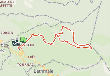

Length
12.1 km

Max alt
1474 m

Uphill gradient
722 m
Km-Effort
22 km

Min alt
715 m

Downhill gradient
764 m
Boucle
Yes
Creation date :
2023-02-22 16:06:12.728
Updated on :
2023-02-25 21:22:39.051
4h58
Difficulty : Medium

FREE GPS app for hiking
 SityTrail
IGN / Geographical institutes
SityTrail Plus
The world is yours!
About
Trail Walking of 12.1 km to be discovered at Occitania, Ariège, Arrien-en-Bethmale. This trail is proposed by chrisgps.
Positioning
Country:
France
Region :
Occitania
Department/Province :
Ariège
Municipality :
Arrien-en-Bethmale
Location:
Unknown
Start:(Dec)
Start:(UTM)
340156 ; 4751442 (31T) N.
Comments