


Valchevriere

pconte
User
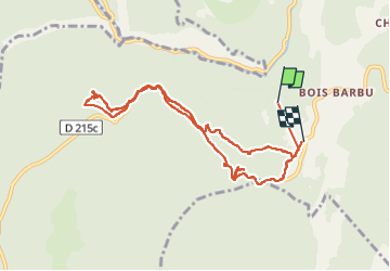

Length
9.5 km

Max alt
1216 m

Uphill gradient
303 m
Km-Effort
13.4 km

Min alt
1081 m

Downhill gradient
250 m
Boucle
No
Creation date :
2023-02-23 14:04:20.0
Updated on :
2023-02-23 16:42:35.713
2h37
Difficulty : Difficult

FREE GPS app for hiking
 SityTrail
IGN / Geographical institutes
SityTrail Plus
The world is yours!
About
Trail Walking of 9.5 km to be discovered at Auvergne-Rhône-Alpes, Isère, Villard-de-Lans. This trail is proposed by pconte.
Positioning
Country:
France
Region :
Auvergne-Rhône-Alpes
Department/Province :
Isère
Municipality :
Villard-de-Lans
Location:
Unknown
Start:(Dec)
Start:(UTM)
698284 ; 4993209 (31T) N.
Comments