


sous chateau

jmheydorff
User
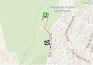

Length
149 m

Max alt
132 m

Uphill gradient
0 m
Km-Effort
212 m

Min alt
100 m

Downhill gradient
19 m
Boucle
No
Creation date :
2023-02-24 09:55:27.584
Updated on :
2023-02-24 10:00:42.146
3m
Difficulty : Easy

FREE GPS app for hiking
 SityTrail
IGN / Geographical institutes
SityTrail Plus
The world is yours!
About
Trail Walking of 149 m to be discovered at Provence-Alpes-Côte d'Azur, Var, Hyères. This trail is proposed by jmheydorff.
Positioning
Country:
France
Region :
Provence-Alpes-Côte d'Azur
Department/Province :
Var
Municipality :
Hyères
Location:
Unknown
Start:(Dec)
Start:(UTM)
266137 ; 4778473 (32T) N.
Comments