


t801136806_entre ouysse et causse a rocamadour

Gpoujade
User
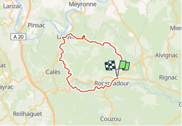

Length
25 km

Max alt
304 m

Uphill gradient
477 m
Km-Effort
32 km

Min alt
98 m

Downhill gradient
476 m
Boucle
Yes
Creation date :
2023-02-24 12:08:09.0
Updated on :
2024-01-16 16:27:59.882
2h11
Difficulty : Difficult

FREE GPS app for hiking
 SityTrail
IGN / Geographical institutes
SityTrail Plus
The world is yours!
About
Trail Mountain bike of 25 km to be discovered at Occitania, Lot, Rocamadour. This trail is proposed by Gpoujade.
Description
Boucle au départ de L'Hospitalet
Positioning
Country:
France
Region :
Occitania
Department/Province :
Lot
Municipality :
Rocamadour
Location:
Unknown
Start:(Dec)
Start:(UTM)
391372 ; 4962284 (31T) N.
Comments