


Rolland Jean Pierre
User
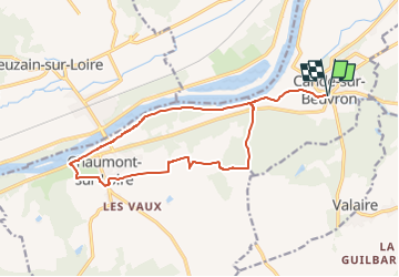

Length
15.5 km

Max alt
120 m

Uphill gradient
115 m
Km-Effort
17.1 km

Min alt
58 m

Downhill gradient
115 m
Boucle
Yes
Creation date :
2023-02-24 20:37:37.425
Updated on :
2023-02-24 20:37:37.425

FREE GPS app for hiking
 SityTrail
IGN / Geographical institutes
SityTrail Plus
The world is yours!
About
Trail of 15.5 km to be discovered at Centre-Loire Valley, Loir-et-Cher, Candé-sur-Beuvron. This trail is proposed by Rolland Jean Pierre .
Positioning
Country:
France
Region :
Centre-Loire Valley
Department/Province :
Loir-et-Cher
Municipality :
Candé-sur-Beuvron
Location:
Unknown
Start:(Dec)
Start:(UTM)
368941 ; 5261515 (31T) N.
Comments