


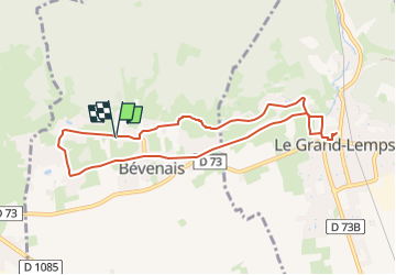
RD-Le-Grand-Lemps-Bevenais

raymondfn
User

Length
8.6 km

Max alt
516 m

Uphill gradient
137 m
Km-Effort
10.4 km

Min alt
445 m

Downhill gradient
135 m
Boucle
Yes
Creation date :
2023-02-25 09:23:44.357
Updated on :
2024-02-19 10:46:42.599
2h22
Difficulty : Medium

FREE GPS app for hiking
 SityTrail
IGN / Geographical institutes
SityTrail Plus
The world is yours!
About
Trail Walking of 8.6 km to be discovered at Auvergne-Rhône-Alpes, Isère, Bévenais. This trail is proposed by raymondfn.
Positioning
Country:
France
Region :
Auvergne-Rhône-Alpes
Department/Province :
Isère
Municipality :
Bévenais
Location:
Unknown
Start:(Dec)
Start:(UTM)
686715 ; 5030017 (31T) N.
Comments
