simiane

ARPF
User

Length
16.1 km

Max alt
641 m

Uphill gradient
528 m
Km-Effort
23 km

Min alt
298 m

Downhill gradient
527 m
Boucle
Yes
Creation date :
2014-12-10 00:00:00.0
Updated on :
2014-12-10 00:00:00.0
6h45
Difficulty : Medium

FREE GPS app for hiking
 SityTrail
IGN / Geographical institutes
SityTrail Plus
The world is yours!
About
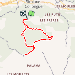
Trail Walking of 16.1 km to be discovered at Provence-Alpes-Côte d'Azur, Bouches-du-Rhône, Simiane-Collongue. This trail is proposed by ARPF.
Positioning
Country:
France
Region :
Provence-Alpes-Côte d'Azur
Department/Province :
Bouches-du-Rhône
Municipality :
Simiane-Collongue
Location:
Unknown
Start:(Dec)
Start:(UTM)
696731 ; 4809720 (31T) N.
Comments