


mennetou sur cher

lecmic
User
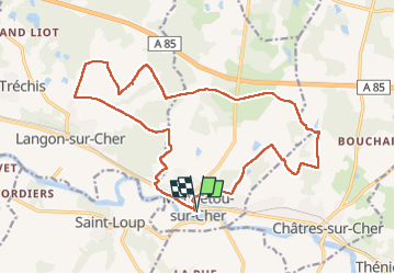

Length
19.6 km

Max alt
136 m

Uphill gradient
175 m
Km-Effort
22 km

Min alt
87 m

Downhill gradient
175 m
Boucle
Yes
Creation date :
2023-02-26 06:16:05.966
Updated on :
2023-02-26 09:26:02.692
3h09
Difficulty : Easy

FREE GPS app for hiking
 SityTrail
IGN / Geographical institutes
SityTrail Plus
The world is yours!
About
Trail Walking of 19.6 km to be discovered at Centre-Loire Valley, Loir-et-Cher, Mennetou-sur-Cher. This trail is proposed by lecmic.
Description
rando
Positioning
Country:
France
Region :
Centre-Loire Valley
Department/Province :
Loir-et-Cher
Municipality :
Mennetou-sur-Cher
Location:
Unknown
Start:(Dec)
Start:(UTM)
414269 ; 5235553 (31T) N.
Comments