


figuerolles.marie j.f. m.claude

NADINE52
User
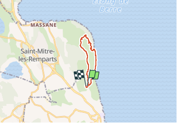

Length
8.2 km

Max alt
123 m

Uphill gradient
159 m
Km-Effort
10.3 km

Min alt
-3 m

Downhill gradient
155 m
Boucle
Yes
Creation date :
2023-02-26 09:05:40.183
Updated on :
2023-02-26 11:34:44.835
2h12
Difficulty : Medium

FREE GPS app for hiking
 SityTrail
IGN / Geographical institutes
SityTrail Plus
The world is yours!
About
Trail Walking of 8.2 km to be discovered at Provence-Alpes-Côte d'Azur, Bouches-du-Rhône, Martigues. This trail is proposed by NADINE52.
Positioning
Country:
France
Region :
Provence-Alpes-Côte d'Azur
Department/Province :
Bouches-du-Rhône
Municipality :
Martigues
Location:
Unknown
Start:(Dec)
Start:(UTM)
665794 ; 4811412 (31T) N.
Comments