


connac

CASSISFRAMBOISE
User
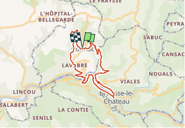

Length
16.7 km

Max alt
541 m

Uphill gradient
600 m
Km-Effort
25 km

Min alt
231 m

Downhill gradient
600 m
Boucle
Yes
Creation date :
2023-02-26 07:36:13.288
Updated on :
2023-02-26 12:27:49.272
4h03
Difficulty : Medium

FREE GPS app for hiking
 SityTrail
IGN / Geographical institutes
SityTrail Plus
The world is yours!
About
Trail Walking of 16.7 km to be discovered at Occitania, Aveyron, Connac. This trail is proposed by CASSISFRAMBOISE.
Positioning
Country:
France
Region :
Occitania
Department/Province :
Aveyron
Municipality :
Connac
Location:
Unknown
Start:(Dec)
Start:(UTM)
468055 ; 4874190 (31T) N.
Comments