


La chapelle des Buis - Beure

i20
User
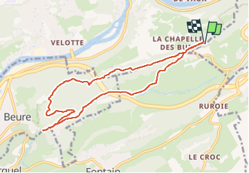

Length
9 km

Max alt
494 m

Uphill gradient
225 m
Km-Effort
12 km

Min alt
301 m

Downhill gradient
226 m
Boucle
Yes
Creation date :
2023-02-26 10:29:35.095
Updated on :
2023-02-26 12:45:32.598
2h15
Difficulty : Medium

FREE GPS app for hiking
 SityTrail
IGN / Geographical institutes
SityTrail Plus
The world is yours!
About
Trail Walking of 9 km to be discovered at Bourgogne-Franche-Comté, Doubs, Morre. This trail is proposed by i20.
Positioning
Country:
France
Region :
Bourgogne-Franche-Comté
Department/Province :
Doubs
Municipality :
Morre
Location:
Unknown
Start:(Dec)
Start:(UTM)
276746 ; 5233785 (32T) N.
Comments