


bruges 2

Clo0413
User
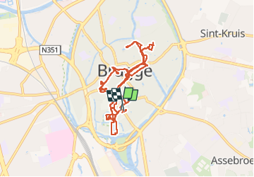

Length
12.7 km

Max alt
15 m

Uphill gradient
54 m
Km-Effort
13.4 km

Min alt
3 m

Downhill gradient
54 m
Boucle
Yes
Creation date :
2023-02-27 08:47:07.322
Updated on :
2023-02-27 13:59:08.477
3h00
Difficulty : Difficult

FREE GPS app for hiking
 SityTrail
IGN / Geographical institutes
SityTrail Plus
The world is yours!
About
Trail Walking of 12.7 km to be discovered at Flanders, West Flanders, Bruges. This trail is proposed by Clo0413.
Positioning
Country:
Belgium
Region :
Flanders
Department/Province :
West Flanders
Municipality :
Bruges
Location:
Brugge
Start:(Dec)
Start:(UTM)
515771 ; 5672363 (31U) N.
Comments