


Puyloubier - légion étrangère

mhetpierre
User
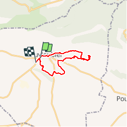

Length
13.2 km

Max alt
363 m

Uphill gradient
199 m
Km-Effort
15.8 km

Min alt
289 m

Downhill gradient
198 m
Boucle
No
Creation date :
2018-08-18 15:30:53.712
Updated on :
2018-08-18 15:30:53.712
5h29
Difficulty : Easy

FREE GPS app for hiking
 SityTrail
IGN / Geographical institutes
SityTrail Plus
The world is yours!
About
Trail Walking of 13.2 km to be discovered at Provence-Alpes-Côte d'Azur, Bouches-du-Rhône, Puyloubier. This trail is proposed by mhetpierre.
Positioning
Country:
France
Region :
Provence-Alpes-Côte d'Azur
Department/Province :
Bouches-du-Rhône
Municipality :
Puyloubier
Location:
Unknown
Start:(Dec)
Start:(UTM)
715816 ; 4822468 (31T) N.
Comments