


le havre db 18km

doboul
User
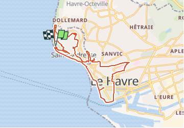

Length
18.4 km

Max alt
97 m

Uphill gradient
332 m
Km-Effort
23 km

Min alt
0 m

Downhill gradient
334 m
Boucle
Yes
Creation date :
2023-02-27 15:00:49.239
Updated on :
2023-02-27 15:01:33.449
5h11
Difficulty : Medium

FREE GPS app for hiking
 SityTrail
IGN / Geographical institutes
SityTrail Plus
The world is yours!
About
Trail On foot of 18.4 km to be discovered at Normandy, Seine-Maritime, Sainte-Adresse. This trail is proposed by doboul.
Positioning
Country:
France
Region :
Normandy
Department/Province :
Seine-Maritime
Municipality :
Sainte-Adresse
Location:
Unknown
Start:(Dec)
Start:(UTM)
287804 ; 5488163 (31U) N.
Comments