


Dan47 Hun Anhée

istadaniel
User
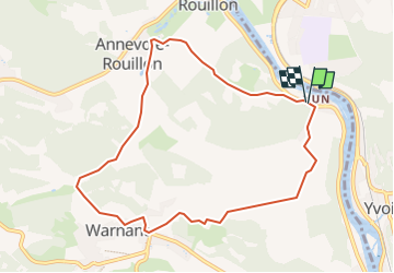

Length
8.3 km

Max alt
200 m

Uphill gradient
245 m
Km-Effort
11.5 km

Min alt
95 m

Downhill gradient
235 m
Boucle
Yes
Creation date :
2023-02-28 09:00:45.295
Updated on :
2023-02-28 09:01:43.419
2h37
Difficulty : Easy

FREE GPS app for hiking
 SityTrail
IGN / Geographical institutes
SityTrail Plus
The world is yours!
About
Trail On foot of 8.3 km to be discovered at Wallonia, Namur, Anhée. This trail is proposed by istadaniel.
Positioning
Country:
Belgium
Region :
Wallonia
Department/Province :
Namur
Municipality :
Anhée
Location:
Unknown
Start:(Dec)
Start:(UTM)
632800 ; 5577728 (31U) N.
Comments