


Valencia de Alcantara

taguette
User
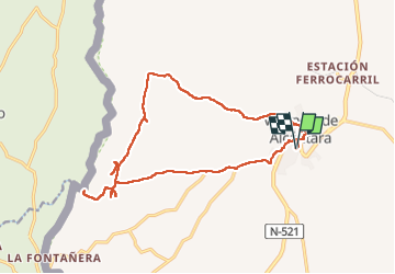

Length
21 km

Max alt
487 m

Uphill gradient
378 m
Km-Effort
26 km

Min alt
399 m

Downhill gradient
377 m
Boucle
Yes
Creation date :
2023-02-28 09:29:52.448
Updated on :
2023-02-28 14:38:58.398
4h58
Difficulty : Difficult

FREE GPS app for hiking
 SityTrail
IGN / Geographical institutes
SityTrail Plus
The world is yours!
About
Trail Walking of 21 km to be discovered at Extremadura, Cáceres, Valencia de Alcántara. This trail is proposed by taguette.
Description
Belle balade dans les environs de Valencia. Le premier menhir suffit à être visité. Un peu déçu par le moulin. le tour de la forteresse n'apporte pas grand chose.
Positioning
Country:
Spain
Region :
Extremadura
Department/Province :
Cáceres
Municipality :
Valencia de Alcántara
Location:
Unknown
Start:(Dec)
Start:(UTM)
651231 ; 4363577 (29S) N.
Comments