


2023-02-28_19h13m56_375 Circuit des Mlavalettes-1

clintest
User
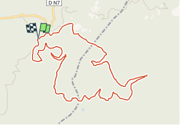

Length
14.1 km

Max alt
406 m

Uphill gradient
359 m
Km-Effort
18.8 km

Min alt
131 m

Downhill gradient
358 m
Boucle
Yes
Creation date :
2023-02-28 18:13:57.341
Updated on :
2023-02-28 18:13:57.118

FREE GPS app for hiking
 SityTrail
IGN / Geographical institutes
SityTrail Plus
The world is yours!
About
Trail of 14.1 km to be discovered at Provence-Alpes-Côte d'Azur, Var, Fréjus. This trail is proposed by clintest.
Positioning
Country:
France
Region :
Provence-Alpes-Côte d'Azur
Department/Province :
Var
Municipality :
Fréjus
Location:
Unknown
Start:(Dec)
Start:(UTM)
322273 ; 4818228 (32T) N.
Comments
très belle randonnée.magnifiques vues.chemins agréables