


Fays-les-Veneurs

geoffrayLayeux
User
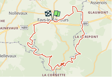

Length
21 km

Max alt
449 m

Uphill gradient
463 m
Km-Effort
27 km

Min alt
292 m

Downhill gradient
463 m
Boucle
Yes
Creation date :
2023-03-01 15:32:18.594
Updated on :
2023-03-01 15:53:28.867
5h53
Difficulty : Very difficult

FREE GPS app for hiking
 SityTrail
IGN / Geographical institutes
SityTrail Plus
The world is yours!
About
Trail Walking of 21 km to be discovered at Wallonia, Luxembourg, Paliseul. This trail is proposed by geoffrayLayeux.
Positioning
Country:
Belgium
Region :
Wallonia
Department/Province :
Luxembourg
Municipality :
Paliseul
Location:
Unknown
Start:(Dec)
Start:(UTM)
655248 ; 5525940 (31U) N.
Comments