


Col de la Bique - Chapelles de Vérignon

soca
User
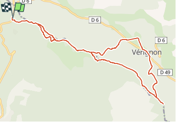

Length
12.5 km

Max alt
1074 m

Uphill gradient
474 m
Km-Effort
18.8 km

Min alt
785 m

Downhill gradient
474 m
Boucle
Yes
Creation date :
2023-03-01 17:41:44.226
Updated on :
2023-03-01 17:43:39.096
4h30
Difficulty : Medium

FREE GPS app for hiking
 SityTrail
IGN / Geographical institutes
SityTrail Plus
The world is yours!
About
Trail Walking of 12.5 km to be discovered at Provence-Alpes-Côte d'Azur, Var, Aups. This trail is proposed by soca.
Positioning
Country:
France
Region :
Provence-Alpes-Côte d'Azur
Department/Province :
Var
Municipality :
Aups
Location:
Unknown
Start:(Dec)
Start:(UTM)
276405 ; 4838068 (32T) N.
Comments