


65-raquettes-cauterets-pont-d-espagne-circuit-balise

topolino
User
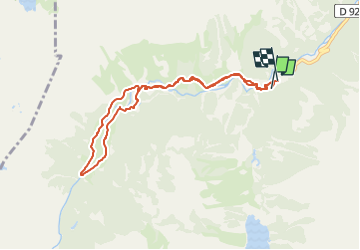

Length
8.7 km

Max alt
1649 m

Uphill gradient
249 m
Km-Effort
12.1 km

Min alt
1465 m

Downhill gradient
261 m
Boucle
Yes
Creation date :
2023-03-01 18:29:04.747
Updated on :
2023-03-01 18:29:04.747
--
Difficulty : Unknown

FREE GPS app for hiking
 SityTrail
IGN / Geographical institutes
SityTrail Plus
The world is yours!
About
Trail Snowshoes of 8.7 km to be discovered at Occitania, Hautespyrenees, Cauterets. This trail is proposed by topolino.
Description
1ère sortie de l année 2012
Positioning
Country:
France
Region :
Occitania
Department/Province :
Hautespyrenees
Municipality :
Cauterets
Location:
Unknown
Start:(Dec)
Start:(UTM)
733905 ; 4748236 (30T) N.
Comments