


le mas des baumes Ferrieres

philcll
User
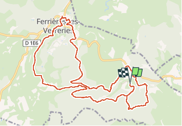

Length
14.9 km

Max alt
322 m

Uphill gradient
208 m
Km-Effort
17.7 km

Min alt
230 m

Downhill gradient
207 m
Boucle
Yes
Creation date :
2023-03-02 07:55:54.807
Updated on :
2023-03-02 12:55:40.609
4h31
Difficulty : Medium

FREE GPS app for hiking
 SityTrail
IGN / Geographical institutes
SityTrail Plus
The world is yours!
About
Trail Walking of 14.9 km to be discovered at Occitania, Hérault, Ferrières-les-Verreries. This trail is proposed by philcll.
Positioning
Country:
France
Region :
Occitania
Department/Province :
Hérault
Municipality :
Ferrières-les-Verreries
Location:
Unknown
Start:(Dec)
Start:(UTM)
566073 ; 4857069 (31T) N.
Comments