


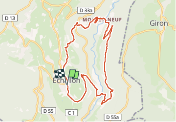
Echallon: moyenne Semine

HB01
User

Length
10.5 km

Max alt
792 m

Uphill gradient
430 m
Km-Effort
16.2 km

Min alt
545 m

Downhill gradient
428 m
Boucle
Yes
Creation date :
2023-03-02 09:36:25.971
Updated on :
2023-03-02 15:45:30.723
2h52
Difficulty : Easy

FREE GPS app for hiking
 SityTrail
IGN / Geographical institutes
SityTrail Plus
The world is yours!
About
Trail Walking of 10.5 km to be discovered at Auvergne-Rhône-Alpes, Ain, Échallon. This trail is proposed by HB01.
Description
Départ Echallon village
Photos

Positioning
Country:
France
Region :
Auvergne-Rhône-Alpes
Department/Province :
Ain
Municipality :
Échallon
Location:
Unknown
Start:(Dec)
Start:(UTM)
711408 ; 5120992 (31T) N.
Comments