


Ah0203

pe78
User
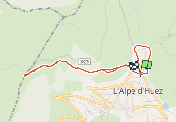

Length
4.8 km

Max alt
1960 m

Uphill gradient
132 m
Km-Effort
6.6 km

Min alt
1841 m

Downhill gradient
134 m
Boucle
Yes
Creation date :
2023-03-02 13:08:28.0
Updated on :
2023-03-02 14:50:58.829
1h41
Difficulty : Medium

FREE GPS app for hiking
 SityTrail
IGN / Geographical institutes
SityTrail Plus
The world is yours!
About
Trail Walking of 4.8 km to be discovered at Auvergne-Rhône-Alpes, Isère, Huez. This trail is proposed by pe78.
Positioning
Country:
France
Region :
Auvergne-Rhône-Alpes
Department/Province :
Isère
Municipality :
Huez
Location:
Unknown
Start:(Dec)
Start:(UTM)
269475 ; 4997604 (32T) N.
Comments