


Evenos le Broussan le Croupatier

Yot
User
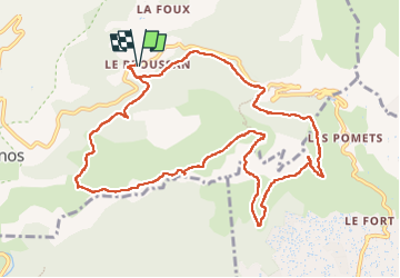

Length
12.7 km

Max alt
507 m

Uphill gradient
533 m
Km-Effort
19.8 km

Min alt
279 m

Downhill gradient
535 m
Boucle
Yes
Creation date :
2023-03-02 08:14:21.887
Updated on :
2023-03-02 15:07:48.614
5h50
Difficulty : Very difficult

FREE GPS app for hiking
 SityTrail
IGN / Geographical institutes
SityTrail Plus
The world is yours!
About
Trail Walking of 12.7 km to be discovered at Provence-Alpes-Côte d'Azur, Var, Évenos. This trail is proposed by Yot.
Positioning
Country:
France
Region :
Provence-Alpes-Côte d'Azur
Department/Province :
Var
Municipality :
Évenos
Location:
Unknown
Start:(Dec)
Start:(UTM)
733180 ; 4784004 (31T) N.
Comments